TrakMaps ChartsMontreal-Sorel
TRAK
TRAK

TrakMaps ChartsMontreal-Sorel

Product Code: 0606300
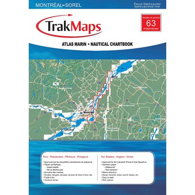
Full colour map showing bathymetry (depth) of the river including buoy localization, services, fishing tips, flora and animal life. The TRAK Nautical Atlas is convenient and practical for boaters with Its laminated pages in an easy to handle size. Format : Laminated booklet ( 24 pages, spiral binding) Scale 1:25000
Online Availability
Availability: <br><b style="color:red;">Special Order, Call us!</b>
  • Manufacturer's number : TRK 063
  • Dimension : 12 x 18
  • Area : Montreal to Sorel
063

Substitute Products

List of suggested products: Substitute Products.
CHS Chart Chaleur Bay - South shore
Sale Price CAD $20.00
Availability: <b style="color:green;">In stock</b>
CHS Chart Chaleur Bay to Iles-de-la-Madelaine
Sale Price CAD $20.00
Availability: <b style="color:green;">In stock</b>
CHS Chart Cap aux Oies / Sault-au-Cochon
Sale Price CAD $20.00
Availability: <b style="color:green;">In stock</b>
TrakMaps Quebec / Tadoussac
Sale Price CAD $62.99
Availability: <b style="color:green;">In stock</b>
Our website requires cookies to enhance your online browsing experience. For example, these cookies allow you to save products in your shopping cart, even when you’re not logged into your account. These cookies are crucial for ensuring the website functions correctly.